Search Maps
-
 MapChattahoochee National Forest (Armuchee Ranger District), Georgia, 1982 Relief shown by spot heights. Panel title: Chattahoochee National Forest, Armuchee Ranger District, Florida. "Forest Service map." "Constructed 1964 in the Regional Office, Atlanta, Georgia, from USDA Forest Service and U.S. Geological Survey maps. Revised 1982 by the F.S. Geometronics Service Center from recent U.S. Geological Survey quadrangles and field review by the Southern Region." Includes indexed table of recreation facilities, index map of...
- Contributor: Geometronics Service Center (U.S.) - United States. Forest Service. Southern Region
- Date: 1982-01-01
-
 MapAtlanta : from Vincent's subdivision map, published by the City Council From Vincent's subdivision map of the city of Atlanta, Dekalb County, state of Georgia. Savannah : Edward A. Vincent, 185-. LC Civil War maps (2nd ed.), S44 Available also through the Library of Congress Web site as a raster image. Includes numbered building index. LC copy imperfect: Fold-lined, mounted on paper.
- Contributor: United States. Army of the Cumberland. Topographical Engineers Office
- Date: 1864-01-01
-
 MapMap of the cost [sic] of Georgia & Florida. Scale 1:253,440; 1/4 in. to 1 mile. Manuscript; pen-and-ink and watercolor. Covers the coast between Savannah and St. Augustine. Shows swamps and marshes. LC Civil War maps (2nd ed.) 129.7 Available also through the Library of Congress Web site as a raster image. Vault AACR2
- Contributor: Hawley, Joseph R. (Joseph Roswell)
- Date: 1863-01-01
-
 MapKennesaw Mountain, Kennesaw Mountain National Battlefield Park, Georgia "*GPO: 1985--461-444/20073." Relief shown by shading. Panel title. Includes text and ill. Text, col. ill., and map of "The Atlanta Campaign" on verso. Available also through the Library of Congress Web site as a raster image.
- Contributor: United States. National Park Service
- Date: 1985-01-01
-
 MapMap[s] illustrating the military operations of the Atlanta campaign ... 1864 Relief shown by hachures. Shows Union Army lines of march, dates, troop positions, and campsites in northwestern Georgia between Chattanooga and Atlanta. The coverage of these 5 maps is indicated on J.v. Glümer's Map illustrating the operations of the army under command of General W.T. Sherman, in Georgia, from May the 5th to September the 4th, 1864 (CW 127, S181). LC Civil War maps...
- Contributor: United States. War Department. Office of the Chief of Engineers - Julius Bien & Co
- Date: 1875-01-01
-
 MapSketch of sea coast of South Carolina and Georgia from Bull's Bay to Ossabaw Sound Scale 1:200,000. Sectioned and mounted on cloth backing. Hand colored. Oriented with north toward the upper right. LC Civil War maps (2nd ed.) 363 LC copy annotated in ink in cover. Available also through the Library of Congress Web site as a raster image. Includes list of "References" to Civil War engagements. AACR2
- Contributor: Hawley, Joseph R. (Joseph Roswell) - United States Coast Survey - Molitor, E. - Lindenkohl, A.
- Date: 1863-01-01
-
 Map[Map of the environs of Olley Creek near Marietta, Georgia]. Shows troop positions. Title from Stephenson's Civil War maps, 1989. LC Civil War maps (2nd ed.), S95, 197 Available also through the Library of Congress Web site as a raster image. Pencil and pen-and-ink (some col.), mounted on paper.
- Date: 1864-01-01
-
 MapMartin Luther King, Jr., National Historic Site, Georgia
Martin Luther King, Junior, National Historic Site, Georgia | Sweet Auburn, the Black Atlanta of King's early years "*GPO: 1996--404-952/40011. Reprint 1996." Panel title. Includes text, descriptive notes, and col. ill. Text and ill. on verso. Available also through the Library of Congress Web site as a raster image.- Contributor: United States. National Park Service
- Date: 1996-01-01
-
 MapA plann of the town of Savannah in the state of Georgia. "This plann is laid down according to the original design but the distances are marked by the survey made & confirmed by Act of Assembly in the year of our lord 1761. [illegible initials]." Oriented with north toward lower right. Pen-and-ink. Available also through the Library of Congress Web site as a raster image. Includes notes and names of select property owners. Fold-lined. Minor...
- Contributor: Marian S. Carson Collection (Library of Congress)
- Date: 1761-01-01
-
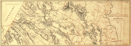 MapMap of the country embracing the various routes surveyed for the Western & Atlantic Rail Road of Georgia, under the direction of Lieut. Col. S. H. Long, Chief Engineer, 1837, U.S. Topographical ... Includes area from Chattahoochee River between Warsaw and Cambelltown, and west to the Tennessee boundary. Shows cities, townships, roads, drainage, and relief by hachures. The 138-mile route was opened in 1850.
- Contributor: Western and Atlantic Railroad Company - Cooper, J. F. - Arms, F. C.
- Date: 1837-01-01
-
 MapMap of Atlanta and vicinity. [July 1864]. Scale ca. 1:165,000. LC Civil War Maps (2nd ed.), 144 From Century illustrated monthly magazine, v. 34, July 1887. p.457. Shows fortifications, roads, railroads, rivers, and towns. The battles of peach Tree Creek (July 20), Atlanta (July 22), and Ezra Church (July 28) are indicated. Description derived from published bibliography. Available also through the Library of Congress web site as raster image.
- Contributor: Western and Atlantic Railroad Company
- Date: 1887-01-01
-
 MapChattahoochee National Forest, Georgia. Scale ca. 1:255,000. Folded title: Welcome to Chattahoochee National Forest, Georgia. Relief shown by hachures and spot heights. Includes col. illus., table of recreation facilities, and inset. Text and illus. on verso. Available also through the Library of Congress Web site as a raster image. AACR2
- Contributor: United States. Forest Service. Southern Region
- Date: 1965-01-01
-
 MapCumberland Island. Scale ca. 1:93,000. Shows Cumberland Island National Seashore. "240-951/84." Includes text and location map. Text, chronology, and illus. (part col.) on verso. Available also through the Library of Congress Web site as a raster image. AACR2
- Contributor: United States. National Park Service
- Date: 1977-01-01
-
 MapSiège de Savannah fait par les troupes françoises aux ordres du général d'Estaing vice-amiral de France, en 7.bre, et 8.bre 1779. Scale ca. 1:27,000. Manuscript, pen-and-ink, watercolor, and gilt. Relief shown by shading. Pictorial map. Available also through the Library of Congress Web site as a raster image. Includes index to points of interest and descriptive notes. Vault AACR2: 100; 651/1
- Contributor: Ozanne, Pierre
- Date: 1779-01-01
-
 MapMap of the state of Georgia, drawn from actual surveys and the most authentic information Relief shown pictorially. Includes a table showing counties with the distance between the counties' "chief towns" and Milledgeville. Shows land districts and includes numbers of land lots. "Entered according to Act of Congress, Savannah, Geo., 1830." Maps showing explorers' routes, trails & early roads in the United States (LC Trails), 287 Available also through the Library of Congress Web site as a raster image....
- Contributor: Green, Orange - Wellborn, Carlton - Hoogland, William
- Date: 1830-01-01
-
 MapSketch of vicinity of 2 Cav. Div. camp, the proposed camp is where the 3 Brig. now is : [Roswell, Georgia] Relief shown by hachures. Date from Stephenson's Civil War maps, 1989. Pencil, colored pencil, pen and ink. LC Civil War maps (2nd ed.), S103, 204 Available also through the Library of Congress Web site as a raster image. Note written vertically in ink along right margin: "Roswell is a very pretty factory town of about four thousand inhabitants. Mills & private property are not...
- Contributor: Garrard, K. (Kenner)
- Date: 1864-01-01
-
 MapBattle of Chickamauga, Ga., Sept. 19 and 20, 1863 Relief shown by form lines and hachures. Title and information about authorship from label affixed at lower right. Orientation incorrectly indicated; interchanging "N" and "W" corrects error. Available also through the Library of Congress Web site as a raster image. Vault Acquisitions control no. 93-9 CW3
- Contributor: Morris, Walter J.
- Date: 1863-01-01
-
 MapState of Georgia: Slope map. Scale 1:500,000; 1 in. equals approx. 8 miles. Relief shown by contours and spot heights. "Lambert conformal conic projection based on standard parallels 33⁰ and 45⁰." "1927 North American datum." "The slope zones on this map ... were derived from USGS 1:250,000-scale maps and were generated by a semiautomated photomechanical process which translates distance between adjacent contours into percentage of slope." "Experimental printing." "Base...
- Contributor: Geological Survey (U.S.)
- Date: 1973-01-01
-
 MapKennesaw Mountain, Kennesaw Mountain National Battlefield Park, Georgia
Kennesaw Mountain National Battlefield Park, Georgia "*GPO: 1998--432-903/60383. Reprint 1998." Relief shown by shading. Panel title. Includes descriptive index to points of interest, text, and ill. Text, col. ill., and map of "The Atlanta Campaign" on verso. Available also through the Library of Congress Web site as a raster image.- Contributor: United States. National Park Service
- Date: 1998-01-01
-
 MapLloyd's topographical map of Georgia from state surveys before the war showing railways, stations, villages, mills, &c. Scale ca. 1:580,000. LC Civil War Maps (2nd ed.), 129.6 "Entered according to Act of Congress in the year 1864 by J. T. Lloyd." "Price in sheets colored in counties 50 cents. Mounted and varnished. Hand-colored general map with places where battles occurred underlined in red. Another copy is in Fillmore map coll. No. 110-W. The Geography and Map Division also has an uncolored...
- Contributor: Lloyd, James T.
- Date: 1864-01-01
-
 MapChickamauga battlefield. [Sept 19-20, 1863] Scale ca. 1:12,300. LC Civil War Maps (2nd ed.), 155 Shows troop positions and movements, names of commanders, location of battlefield monuments, roads, railroads, fords, bridges, drainage, vegetation, houses, and names of residents. Description derived from published bibliography. Available also through the Library of Congress web site as raster image.
- Contributor: McElroy, Joseph C.
- Date: 1895-01-01
-
 MapMap of Whitfield County, Georgia Relief shown by hachures. Includes notes, list of Georgia militia districts, and advertisement. LC Land ownership maps, 98 Available also through the Library of Congress Web site as a raster image. LC copy mounted on cloth and shellacked.
- Contributor: Street, Samuel M. - Schultz, Wm. P. (William P.) - Smith & Stroup (Firm)
- Date: 1879-01-01
-
 MapAugusta, Ga., 1864.
Augusta, Georgia, 1864 Shows defenses of Augusta. "1864" at end of title in pencil. Similar map appears in the U.S. War Dept.'s Atlas to accompany the official records of the Union and Confederate armies, 1891-95, pl. 132, no. 6. Pen and ink. LC Civil War maps (2nd ed.), S46, 146 Available also through the Library of Congress Web site as a raster image. "Savannah" annotated in pencil...- Date: 1864-01-01
-
 MapGreater Atlanta region. Scale 1:100,000. Relief shown by contours and spot heights. Projection: Universal transverse Mercator. Compiled in 1974 from USGS quadrangles dated 1956-1974. Limited revision from aerial photographs taken 1968, 1972, and 1973, and from available boundary and airport information. "State of Georgia, Department of Natural Resources, Earth and Water Division" appears on upper right-hand corner above border. Includes "Index to USGS 7.5ʹ quadrangles" and location...
- Contributor: Geological Survey (U.S.)
- Date: 1975-01-01
-
 Map[Schofield crossing the Chattahoochee, July 1864]. Shows military camp west of the Chattahoochee River near the Ulrich farm and troop positions in Fulton County between Roswell and Atlanta. Relief shown by hachures and pictorially. Title and date from Stephenson's Civil War maps, 1989. Pencil, blue watercolor, and red watercolor. LC Civil War maps (2nd ed.), S52, 153 Available also through the Library of Congress Web site as a raster image....
- Date: 1864-01-01