Collection Items
-
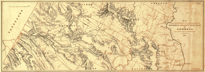 MapMap of the country embracing the various routes surveyed for the Western & Atlantic Rail Road of Georgia, under the direction of Lieut. Col. S. H. Long, Chief Engineer, 1837, U.S. Topographical ... Includes area from Chattahoochee River between Warsaw and Cambelltown, and west to the Tennessee boundary. Shows cities, townships, roads, drainage, and relief by hachures. The 138-mile route was opened in 1850.
- Contributor: Western and Atlantic Railroad Company - Cooper, J. F. - Arms, F. C.
- Date: 1837-01-01