Search Maps
-
 MapTransportation map of Georgia. Scale ca. 1:1,108,800; 1 in. represents approx. 17.5 miles. Shows transportation zones, trackage rights, principal stations, distances between rail intersections, major U.S., Interstate, and State highways, and navigable waterways. Includes "Index to railroads." Available also through the Library of Congress Web site as a raster image. AACR2
- Contributor: Geological Survey (U.S.) - United States. Federal Railroad Administration. Office of Policy and Program Development
- Date: 1975-01-01
-
 MapTransportation map of Georgia. Scale ca. 1:1,108,800; 1 in. represents approx. 17.5 miles. Shows trackage rights, principal stations, distances between rail intersections, major U.S., Interstate, and State highways, and navigable waterways. Includes "Index to railroads." Available also through the Library of Congress Web site as a raster image. AACR2
- Contributor: Geological Survey (U.S.) - United States. Federal Railroad Administration. Office of Policy and Program Development
- Date: 1975-01-01
-
 MapMap of the country embracing the various routes surveyed for the Western & Atlantic Rail Road of Georgia, under the direction of Lieut. Col. S. H. Long, Chief Engineer, 1837, U.S. Topographical ... Includes area from Chattahoochee River between Warsaw and Cambelltown, and west to the Tennessee boundary. Shows cities, townships, roads, drainage, and relief by hachures. The 138-mile route was opened in 1850.
- Contributor: Western and Atlantic Railroad Company - Cooper, J. F. - Arms, F. C.
- Date: 1837-01-01
-
 MapBirds-eye map of the Western and Atlantic R.R., the great Kennesaw route; Army operations, Atlanta campaign, 1864. Map of northwest Georgia from Atlanta north to Chattanooga, Tenn., showing location and date of battles, railroads, principal roads, towns, rivers, and relief by hachures.
- Contributor: Western and Atlantic Railroad Company - Fleming, Brewster & Alley
- Date: 1887-01-01
-
 MapProfile & location of the A. & W. Pt. R.R. of Ga.; surveyed & drawn by Cha's Mahon, C. E., 1865-6. Detailed map of the route and profile of the Atlanta and West Point Railroad from Atlanta to West Point on the Chattahoochee River. Chartered under Atlanta and La Grange Railroad in 1847.
- Contributor: Atlanta and West Point Rail Road Company - Mahon, Charles
Resource: View All Images
-
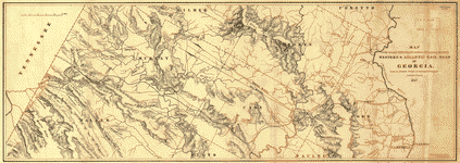
 MapIndexed railroad and county map of Georgia. Indexed map showing relief by hachures, drainage, cities and towns, county and township boundaries. Railroads distinguished by color.
- Contributor: Cram, George Franklin
- Date: 1883-01-01
-
 MapMap showing route taken by U.S. prisoners of war, Feby. 1864, when sent from Richmond, Va., to Andersonville, Georgia. Depicts railroad lines from Raleigh, N.C., through South Carolina and Georgia, highlighting in purple ink the particular train route Sneden took as a prisoner.
- Contributor: Sneden, Robert Knox
-
 MapGeorgia. Shows railroad lines emanating south and east of Atlanta going toward Macon and Columbus, Ga., with a notation "125 miles from Atlanta to Andersonville [Prison]."
- Contributor: Sneden, Robert Knox
- Date: 1861-01-01
-
 Map[Map of South Carolina, Georgia, Alabama, and Tennessee.] Shows the southern border of South Carolina, northern border of Georgia, and eastern borders of Alabama and Tennessee, with railroads, towns, forts, prisons, landforms, and waterways.
- Contributor: Sneden, Robert Knox
- Date: 1861-01-01